
Creation Science Rebuttals -
Stratigraphy and the Young Earth Global Flood Model - Part 4
by Greg Neyman
© Old Earth Ministries
First Published 26 Jan 2003
Old Earth Ministries Website
Revised and Expanded February 2006
In order to proceed further, a little explanation about stratigraphy is in order. Click on the graphic below. It will open a new window. The one on the left is the rock layers of the Glen Canyon National Recreation Area, and the one on the right is the stratigraphy of Arches National Park. Both are located in Utah.
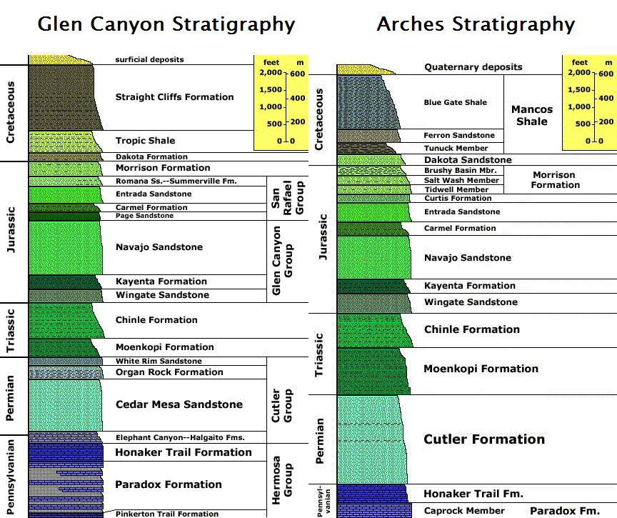
Stratigraphic columns for different locations can vary for several reasons. Name changes from place to place account for some of the changes. At the bottom, notice the Cutler Formation on the right (at Arches Nat'l Park), and on the left, the Cutler Group, which is composed of four formations. The Cutler Formation contains interbedded sandstones, shales, and limestones, but they do not reach any significant thicknesses by themselves to be called a separate formation. As you go southwest from Arches to Glen Canyon, these layers thicken significantly, and can be treated as separate formations, therefore, instead of one formation, we have four.
It can work the other way as well. Note the single formation at Glen Canyon known as the Morrison. When you go north to Arches, it is divided into three members.
There may also be missing formations at one location. In the Permian Period on the left, notice the Organ Rock formation. It is missing on the right. It thins as you go northeast until it disappears. This means the depositional environment that caused this shale to form was prevalent towards the south. Another reason a formation is missing in one locale is because it has two names. What may be the XYZ Formation in one location is the ABC Formation in another location, even though they are exactly the same rock layer.
The main reason for changing rock layers is known as Transgression and Regression. As the sea level rises and falls, the shoreline moves inland and then back out again. This moves the deposition zones for the rock types. Sandstones form at shorelines. When the shore moves in, the sand layer it deposits is moving inland as well. Behind that, the silt layer also advances, covering up the sand layer that used to be the shoreline.
For an excellent web page showing the relation from location to location, click here.
Discussion
Now, let us move on to discuss more stratigraphic layers on our excursion up the stratigraphic column. For this page, we will consider the geology at Flaming Gorge Recreation Area. Since we are moving up, I have removed the lower layers from the graphic below. (Graphic courtesy of the U.S. Geological Survey)
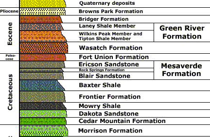
On the previous page, we ended with the Dakota Sandstone. The two layers you see below the Dakota in the graph were not present at the previous location we examined, so we will go back and discuss these.
Morrison Formation
The Morrison Formation is a distinctive body of
rock in the western United States and Canada that has been the most fertile
source of dinosaur fossils in North America. It is composed of mudstone,
sandstone, siltstone, and limestone; and is light grey, greenish gray, or
red. Most of the fossils occur in the green siltstone beds and lower
sandstones, relics of the rivers and floodplains of the Jurassic period.
It is centered in Wyoming and Colorado, and includes
parts of Montana, Saskatchewan, Alberta, North Dakota, South Dakota,
Nebraska, Kansas, the panhandles of Oklahoma and Texas, New Mexico, Arizona,
Utah, and Idaho. It covers an area of 1.5 million square km (600,000 square
miles), though only a tiny fraction is exposed and accessible to geologists
and paleontologists. Over 75% is still buried under the prairie to the east,
and much of the rest was destroyed by erosion as the Rocky Mountains rose to
the west.1
The Morrison is famous for many dinosaur finds.
Trackways, with dinosaur footprints, exist all over the Morrison. On
my desk as I type this, I have a piece of dinosaur coprolite (fossilized
dinosaur dung) from the Morrison. Other key features that have been
found include nest sites, with dinosaur eggs, and feeding sites, where
dinosaur carcasses were scavenged by other dinosaurs.
If we accept the flood model proposed by young earth scientists, which started with the first horizontal layers at the base of the Grand Canyon, we have had over 11,000 feet of sediment deposited by the time we reach the Morrison Formation. However, the Morrison provides clear evidence that dinosaurs were alive and well, eating, walking, and pooping all over the landscape. As a reminder, there are no dinosaur fossils in the first 8,000 feet of sediment deposited by the flood. And at this point, we still have not had any mammals show up in the fossil record. Either the dinosaurs and mammals were excellent swimmers, or the young earth model is wrong.
Even if they were excellent swimmers, we would still expect to find fossils of dinosaurs and mammals at the base of the Grand Canyon, or, in units stratigraphically equivalent to them. At this point in time, we have had over 1,500 years minimum, from the creation to the Flood, for dinosaurs and mammals (and humans) to die. There should be evidence of 1,500 years worth of death for mammals and dinosaurs. There is none.
To my knowledge, this problem has been ignored by the young earth community. When something cannot be answered, it is usually ignored, and left for other young earthers to figure out. This is evidenced by the words of young earth creationist Jonathan Sarfati..."We should remember, if confronted with other ‘unanswerable’ challenges to the biblical world view, that even if we don’t have all the answers, God does. And He, in His good time, may raise up godly scientists to discover them." 2 In other words, if it doesn't fit the young earth model, then it must be flawed, and re-evaluated until it does agree. Therefore, using this assumption, it is impossible to prove an old earth from their perspective, no matter how convincing the evidence.
For More Reading
Wikipedia - Morrison Formation
Wikipedia - Dinosaur National Monument
Dinosaur National Monument - Official Site
Cedar Mountain Formation
Cedar Mountain is early Cretaceous in age, and overlies the Morrison Formation in Utah. It contains three distinct units, and varies up to 450 feet thick. The first represents a dry, seasonal climate, and contains many fossils, to include fish, turtles, crocodiles, and dinosaurs, including my favorite, Utahraptor.
The middle sandstone represents about 10 million years of deposition. In this layer are evidences of flowering plant life, and a large number of nodosaurids (large, land-dwelling, armor plated herbivores).
The third level is characterized as a period of volcanic activity, and was a wetter period of time. This layer contains turtles and crocodiles, many dinosaurs, such as Troodon and Eohadrosaurus, and freshwater fish.
One of the best known localities of the Cedar Mountain Formation is the Dalton Wells Quarry near Moab in east central Utah. This quarry has been known for at least 50 years, but was only recognized as early Cretaceous in 1979. Large numbers of bones, mostly dis-articulated elements, of both juvenile and adult dinosaurs have been unearthed, many of which have not yet been named. At least 7 genera have been recognized, including Utahraptor. The fossils appear to have been deposited in a volcanic ash-choked stream on the shore of a lake.
Here is a standard geologic explanation. Far to the west, in present-day California and Nevada, high mountains rose shedding their sediments eastward. Since Precambrian times, oceans had encroached from the west, but no more. Oceans would now have to invade from the south and east because of the new highlands to the west. Sediment washed from the western mountains accumulated on top of the Morrison and later became the Cedar Mountain Formation. The Cedar Mountain environment was probably much like the Morrison. Dinosaurs roamed this environment, but the types of dinosaurs had changed. Deinonychus, for example, comes out of the Cedar Mountain Formation.
How does this fit with the young earth model. The first unit had a dry, seasonal climate (i.e. spring, summer, fall, winter cycle). However, the flood would have been anything but dry, and seasons would be indistinguishable. The second layer has evidence of the first flowering plants. How could plants have survived the first 10,000+ feet of rock layers being deposited? Unlike animals, plants could not flee the flood. The bottom, first layers of the Flood rocks, in the bottom of the Grand Canyon, should contain many plant fossils, but there are none. Young earth creationists have not answered how plants could appear so high up in the fossil record.
And just like the Morrison Formation, we have living dinosaurs walking all over the landscape, right in the middle of Noah's Flood. For reference, the premiere young earth Grand Canyon book, Grand Canyon: Monument to Catastrophe, lists these rocks (all rocks from the Mesozoic) as "Late Flood" rocks. According to the Bible in Genesis 7:17-23, the waters rose, and all animals were killed, indicating death by Day 40 of the flood. However, if we are to believe the young earth model, we have to account for the clear evidence of dinosaurs being alive at Day 200 or later of the Flood. Granted, some young earth creationists have recognized this problem, but they have not put forth a workable replacement theory, and the theory from this book remains the most popular one.
Dakota Sandstone (previously discussed in Part 3)
Mowry Shale
The Mowry Shale is a member of the larger Mancos Shale. It was the result of the ocean floor subsiding and the sea deepening. There are also ash falls from volcanoes in this shale. Fossils include fish scales, oysters, and large ammonites.
The shale was formed on top of the Dakota Sandstone as a result of sea level change. At this location it is only about 400 feet thick.
Frontier Sandstone
A sandstone member of the Mancos Shale, although at this locale it is considered a formation. The Mowry ocean retreated eastward temporarily, exposing the ocean floor. A little west of present-day Salt Lake City, stood high, newly-formed mountains. Rivers washed sediment down the mountains and piedmont to coastal plains, forming gravelly alluvial fans. Ocean waves and littoral currents constructed sandy beaches, offshore sand bars and dense jungle-like forests grew down to the coastal lagoons behind barrier beaches. As the ocean depth fluctuated, these ecosystems moved east and west over present-day Wyoming, Utah, and Colorado. The coastal waters teamed with shellfish.
This depositional environment hardly sounds like the earth is covered in water. Alluvial fans of course sediments are a clear indication of mountain streams emptying into larger bodies of water. Clear sandy beaches, and evidence of dense jungle growth from the fossil record all testify against the young earth flood model.
Baxter Shale
The Baxter Shale is the equivalent of the Mancos Shale in other localities. Most of the references in the literature use the name Mancos. The Mancos is a gray-black mudstone, and can be up to 2,000 feet thick in localities.
The geologic setting for the Mancos is as follows. The high mountains that arose during Frontier (Sandstone) time perhaps depressed the crust in front of them, causing the Frontier ocean to deepen. The Frontier deposits thinned eastward giving way to deep-water clay and mud that later became the Mancos Shale.
Mesaverde Formation
There are three members of this formation at the location we are examining. The geologic setting is this...the Mancos seaway gradually withdrew to the northeast (85 million years before present) with many temporary re-advances. Beaches and coastal swamps marked this retreat and are preserved in the Mesaverde Formation.
Again, we have evidences of fluctuating sea levels, in the transgression and regression of the shoreline. Sunny beaches right in the middle of Noah's Flood...along with coastal swamps full of plant and animal life, make the young earth model collapse.
Conclusion
We have seen many transgressions and regressions of the shoreline at a time when the whole planet is supposedly underwater. We have many dinosaurs walking around when the whole planet is supposedly underwater. We have many thriving swampy environments at a time that the planet is supposedly underwater. With such evidences, clearly the young earth model is not correct. In the next and final part, we will examine the Cenozoic Era, from 65 million years ago to the present.
1 The Morrison Formation, from Wikipedia, the free internet encyclopedia
http://en.wikipedia.org/wiki/Morrison_Formation
2 Creation Magazine, Volume 21, Issue 2. Published on the web at answersingenesis.org/creation/v21/i2/yellowstone.asp
3 http://www.dinoruss.org/de_4/5ca00ee.htm
If you are not a Christian, and you have been holding out on making a decision for Christ because the Church always preached a message that was contrary to what you saw in the scientific world, then rest assured that the Bible is the inerrant Word of God, and you can believe in Christ and receive salvation, while still believing in an old earth. Click here for more.
Are you a Christian who believes in young earth creationism? Now that we have shown the many difficulties of the young earth creation science model in this and many other articles, how does this impact your Christian life? If you are a young-earth creationism believer, click here.
Print-Friendly PDF Version of this page
Part 4
Other Relevant Old Earth Ministries Articles
Noah’s Flood – Is the Young Earth Creation Science Model for Noah’s Flood right?
A Bridge Over Troubled Waters - A Scientific Look Into the Genesis Flood Account
Can You Be A
Christian and Believe in an Old Earth?
Feel free to check out more of this website. Our goal is to
provide rebuttals to the bad science behind young earth creationism,
and honor God by properly presenting His creation.