Old Earth Ministries Online Geology Curriculum© Old Earth Ministries (We Believe in an Old Earth...and God!) NOTE: If you found this page through a search engine, please visit the intro page first.
|
|
Geology - Chapter 9: Plate TectonicsAlthough the concept of the continental land masses moving originated in the 1800's, it was not until the 1960's that the theory of plate tectonics was developed. In the 1960's, the ocean floors were mapped, and core drilling through the ocean floors examined the magnetic and seismic characteristics of the floor. Now, with exact laser and global positioning system (GPS) measurements, plate tectonics has moved from a theory to a proven fact backed by scientific measurements. |
Lesson Plan
Monday - Read Text Tuesday - Research Wednesday - Quiz Thursday - Review Friday - Test
|
|
Parents Information
This lesson plan is designed
so that your child can complete the chapter in five days. The only
decisions you will need to make will be concerning the research task for
Tuesday. It is up to you to determine if the student will simply fill
in the answers, or provide a short essay answer. You will also need to
determine the percentage that this research will play in the overall chapter
grade, if any. |
|
|
Why did God create a world that involved moving plates? As you will find out, tectonic plates are responsible for building mountains, and they are responsible for volcanic activity. These two methods of building new land counteracts the erosion that occurs, which removes land. Without a method of replacing land lost to erosion, our world would be flat and completely covered in water...great if you are a fish, but not so great for us humans! The system God put in place ensures that the land will renew itself, and give us dry land to live on! Continental Drift When maps were first
made of the continental land masses, scientists noted that the continents
looked like they could fit together, like pieces of a puzzle. Although
this occurred in the 1800's, the first proposal that gained attention was
put forth by Alfred Wegener, who was a German meteorologist. In 1915
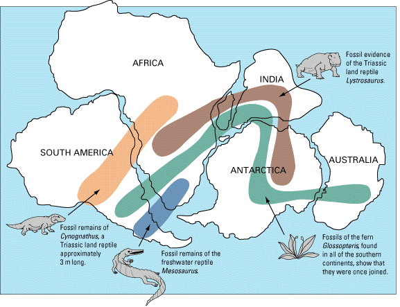
he There is several good lines of evidence supporting Wegener's original theory. Paleontologic Evidence.
Wegener and others noted that certain fossils found on both sides of the
Atlantic ocean were very similar. From this evidence, they reasoned
that Africa and South America had once been connected. Marine fossils
could have migrated across the ocean, but plants and land-dwelling reptiles
could not. Consider the seed fern Glossopteris, which
has been found in rocks of the same age in all of the southern continents.
Fossils have been found in South America, South Africa, Australia, and
India, and even in Antarctica. The seeds of this plant are too large Geologic Features and Rock Types. Some geologic features on continents match, even though they are thousands of miles apart. For example, folded mountain ranges at the southern tip of Africa terminate sharply at the coast, and an equivalent structure of the same age, with the same style of deformation, and the same rock type, appears in Argentina. This is also true of the Appalachian Mountains. They extend northeastward into Newfoundland and terminate abruptly on the coast. They continue on the coast of Ireland and Brittany. Glaciation. Near the end of the Paleozoic Era, glaciers covered a large area of the southern hemisphere. The deposits left by these glaciers are easily identified, and they are present on parts of South America, Africa, Australia, and Antarctica. Striations (groves left in the rocks from the scraping action of ice) give the direction in which the ice moved, which further confirms the way the continents fit together. For more, see Karoo Ice Age. Paleoclimates. The climate of the past can be used as evidence of tectonic movement. For example, there are vast coal deposits in Antarctica, which is now a frozen continent. This indicates it once had abundant plant life and a more hospitable climate. Other continents which have ancient deposits of desert sandstones are hard to explain based on their present positions, yet when combined with where the continents were located millions of years ago, they are easily explained. Why did the geologists of the early 1900's reject the theory of continental drift, when the evidence seemed to support it? They reasoned that there was no mechanism that could cause the such large continental land masses to move. This changed with the study of the earth's ocean basins in the 1960's. Plate Tectonics is Born With the study of the ocean floor in the 1960's, geologists noticed features that clearly favored the theory of continental drift. These features were the topography and geology of the ocean floor, and rock magnetism. Ocean Floor Geology New devices
developed in the 1950's and 1960's enabled geologists to map the topography
of the ocean floor. The topography revealed that the ocean basins are
divided by long ridges. These features were studied in an earlier
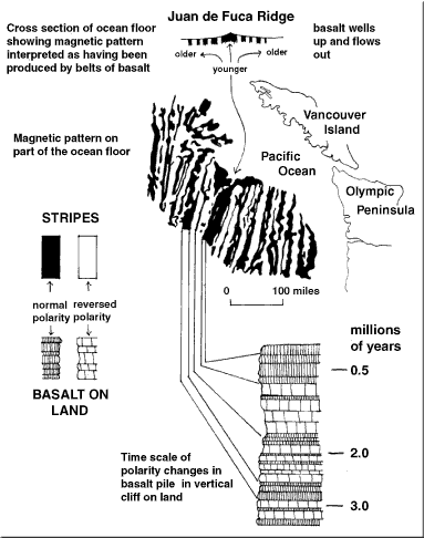
chapter. Another Also in the 1950's, advances in magnetometers, the tools used to measure magnetism in rocks, brought further evidence of plate movement. The rock type being produced at the mid-oceanic ridges is basalt, which contains iron. As the rock cools, the mineral grains become oriented based on the magnetic field. Because of this, a new branch of study arose, called paleomagnetism, which is the study of magnetism of the past. However, it was not just igneous basalt that could be used. Red sandstone also contains iron, so that its grains become oriented also. By studying the orientation of these grains in basalt and sandstone, geologists are able to put together a history of the earth's magnetic field.
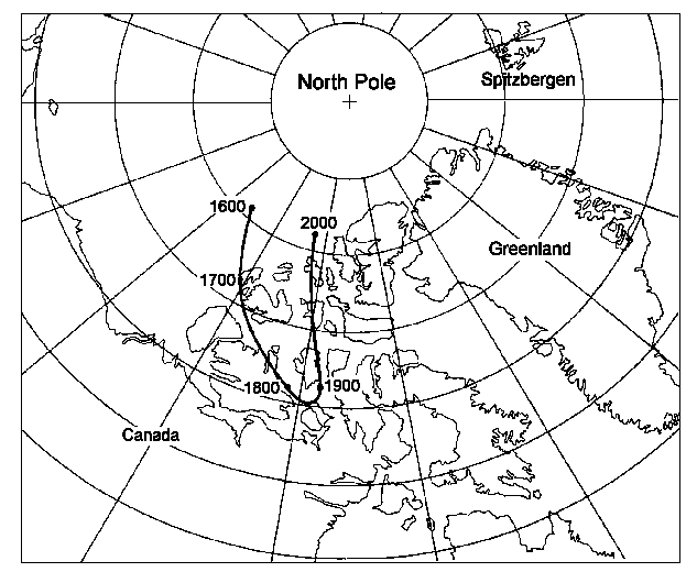
It was discovered that over the millions of years of earth's history, that
the earth's magnetic poles actually wander (called polar wandering).
You may have already noticed evidence of this. If you look at a map,
you may notice that there is a geographic north and south pole, from which
the grids of latitude and longitude are determined. The
Another feature that geologists noted is that the grains were oriented in
the opposite direction in many rocks. Some would indicate an
orientation to the north ("positive" for the magnetic field), whereas others
a short distance away were oriented toward the south. Geologists
determined that the earth's magnetic field reversed itself from time to
time. These magnetic reversals occurred frequently.
For example, during the last 76 million years, there have been at least 171
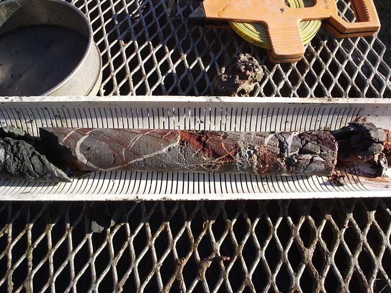
More evidence for plate tectonics comes from the sediments on the ocean floor. Thanks to core drilling, scientists can also examine the fossils that are buried in a particular section of ocean floor. Fossils with known ranges of existence confirm the dates that we obtain from radiometric dating. For example, if we radiometrically date a section of ocean floor basalt at 100 million years old, then the fossils that are contained just above the basalt should be close to the same age. When we examine them, we find that this is the case. In addition, observed rates of sedimentation in the open ocean are about 1.0 centimeters of sediment every 1,000 years. If the ocean basins had existed 500 million years ago, the sediment would be at least 5 kilometers thick. However, ocean bed sediment is not this thick. In fact, the thickest sediments are only 300 meters thick. The oldest ocean sediment dates to about 160 million years old. By comparison, the oldest continental crust material is dated to about 4 billion years old.
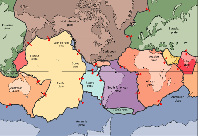
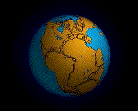
Plate Geography
The earth's crust is made up of tectonic plates that fit together like the
pieces of
Plate Boundaries
Tectonic activity is mostly found at the plate boundaries, where two plates intersect each other. There are three kinds of plate boundaries, each having its own characteristics and causing specific rock deformation.
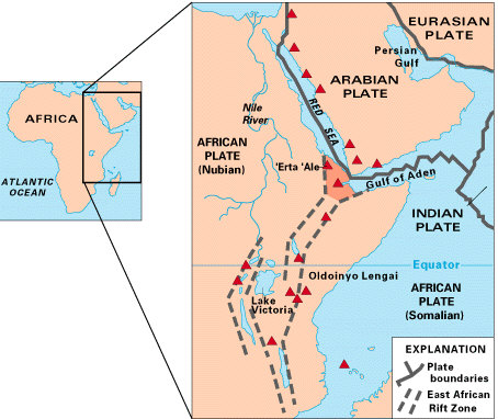
Divergent Plate Boundary
Also known as spreading centers, these are where a plate splits and is pulled apart. Divergent plate boundaries are characterized by tensional stresses, producing block faulting, fractures, and open fissures at the spreading center. The rock type is typically basaltic magma. For two animations showing this process, see Divergent plate boundary and Divergent boundary.
Divergent plate boundaries can also occur on continents.
The Great Rift Valley
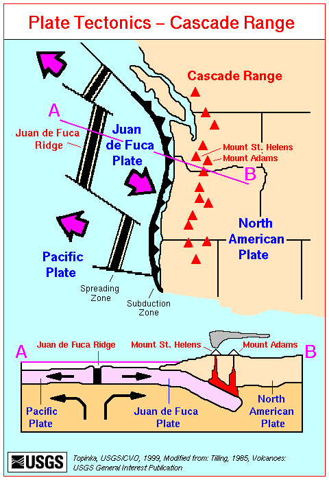
Convergent Plate Boundary
Convergent plate boundaries consist
of three types of plate collisions, based on the type of crust colliding and
its density. First, when the two colliding plates are oceanic, one
plate is thrust under the other. The lower plate dives, or "subducts"
underneath the other plate, hence the term subduction zones.
Second, subduction zones can also occur between continental and oceanic
plates. The oceanic plate always subducts under the continental plate,
because continental rock is less dense than oceanic rock, causing it to
float over the more dense oceanic crust.
Subduction zones are known for their volcanic activity.
Transform Fault Boundary
The third type of plate boundary is the transform fault boundary. Some geologic texts also refer to them as passive plate margins. These are zones where two plates slide past each other without diverging or converging. Another term to describe their relationship is a strike-slip fault. Unlike the other two types of boundaries, there is no volcanic activity with transform faults. You will learn more about these faults in the chapter on earthquakes.
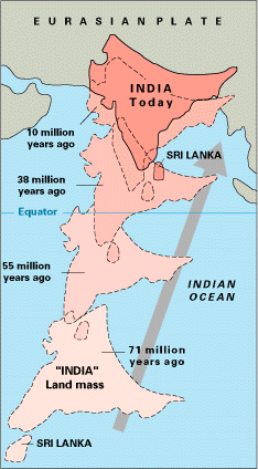
Supercontinent History
During earth's history several supercontinents have been identified. The youngest of these is Pangea, which existed 200 million years ago. Evidence suggests that another supercontinent, named Pannotia, may have existed about 600 million years ago. Pannotia existed for about 50 million years. The supercontinent Rodinia is believed to have formed about 1.1 billion years ago, and it existed until about 750 million years ago. Some scientists have proposed another supercontinent, called Columbia, between 1.8 and 1.5 billion years ago. There may have been earlier supercontinents as well. In addition there have been other smaller supercontinents. The most well-known of these is known as Gondwana, which comprised the landmasses of the continents that are now in the southern hemisphere. Research the answers to the following questions about plate tectonics. Your parents may have you simply answer the questions, or they may have you put it in essay form. Please follow your parents instructions. To answer these questions, utilize a search engine to locate the best webpages, or consult a textbook/encyclopedia. You may also use the links at the bottom of this page.
Today you will complete a 10 question practice quiz. The link to the quiz will open a new window. You can come back here and check your answers. Do not click the Back button on your browser during the quiz. After the quiz, continue your research project, if necessary. Please review the terms in bold in the text, and ensure you have completed your research work from Tuesday. Today you will take the end of chapter test. Please close all other browser windows, and click on the link below. During the test, do not click on the Back button on your browser. After you have completed the test, you may proceed to Chapter 10 on your next school day. Please return to the introduction page for the link to the next chapter. Return to the Old Earth Ministries Online Geology Curriculum homepage. Helpful Links
Research Articles on platetectonics.com
|
 authored a work called The Origin of Continents and Oceans. In a
series of maps, he showed how the land masses had moved, and had originated
from a single landmass, or supercontinent. He called this landmass
authored a work called The Origin of Continents and Oceans. In a
series of maps, he showed how the land masses had moved, and had originated
from a single landmass, or supercontinent. He called this landmass