Old Earth Ministries Online Geology Curriculum© Old Earth Ministries (We Believe in an Old Earth...and God!) NOTE: If you found this page through a search engine, please visit the intro page first.
|
|
Geology - Chapter 8: Geologic Time / Geologic MapsThe average human lifespan is less than 80 years. Because of this, we tend to think that 80 years is a very long time. In reality, it is merely a fleeting moment. 2 Peter 3:8 says that a thousand years to God is like a day. That is because as an eternal being, time has no meaning. To examine the world we live in, we must expand our concept of what a long time period is. Even thousands of years is inadequate...we must think in terms of millions and billions of years. |
Lesson Plan
Monday - Geologic Time Tuesday - Geologic Maps Wednesday - Quiz Thursday - Review Friday - Test
|
|
Parents Information This lesson plan is designed so that your child can complete the chapter in five days. Since there is no research topic in this lesson, no parental decisions need to be made. The grade for this chapter can come solely from the end of chapter test. |
|
|
Geologic Time Geologists interpret the rocks of the earth based on their past history. Prior to the late 1700's, the accepted method of belief in earth's history was based on a concept called catastrophism. Catastrophism says that the earth is very young, about 6,000 to 10,000 years old. It also states that what we see in the rock record is the result of many catastrophic events that were quick in duration, such as volcanic events, or in the case of young earth creationism, the year-long global flood. In the late 1700's, the first geologists started to question this interpretation. They saw evidence in the fossil record that indicated the earth's features evolved over many millennia, from slow and gradual processes. The first person to challenge catastrophism was James Hutton, who is considered the father of modern geology. He developed a new concept that became known as uniformitarianism. This concept states that past geologic events can be explained by observing present-day events, such as sedimentary deposition, volcanism, and gradual uplift of the earth's crust. Later, we would come to understand the mechanism behind many of these processes, plate tectonics. One of the earliest influential geology texts was called Principles of Geology, by Sir Charles Lyell. He based his book upon Hutton's new uniformitarian principle. At such an early stage in geological science, Hutton and Lyell saw the earth constantly reforming itself, with no beginning. It was only later, with more study, and improved astronomical models such as the Big Bang, that we now know the earth had a beginning, about 4.5 billion years ago. With more modern geologists examining the earth, we have come to refine the principles of uniformitarianism. Simply put, it states that natural laws do not change with time. What we observe happening today...the deposition of sand in a river system...the accumulation of silt in a river delta, or the eruption of volcanoes, has happened exactly this way in the past. Our ability to express these laws may change, but the laws themselves do not. There are still scientists who believe the earth is only six to ten thousand years old. These young earth creationists are forced to interpret rock formation so that it fits within their short time frame. This forcing of time scales upon observed scientific data leads young earth creationists to commit many scientific errors. The scientific data must be either twisted, or omitted, to make it fit a young earth time scale. By contrast, old earth believers do not have to twist science, nor the Bible, to make the two agree. Relative Dating Early geologists did not have tools such as radiometric dating. Instead, they had to rely upon the observed relationships between the rock units. This relationship is called relative dating. Using relative dating, many events that occurred millions of years ago can be arranged in a sequence, which shows the order that they occurred in. There are four principles used to determine relative dating. They are: 1. The principle of superposition. 2. The principle of faunal succession. 3. The principle of crosscutting relations. 4. The principle of inclusion. Before we go further, one more point should be understood. Relative dating does not imply a specific amount of time. It merely indicates that one event happened before another event. The length of time between events is not resolved by relative dating.
The
Principle of Superposition states that in a sequence of
undeformed Superposition contains two assumptions. First, the layers were horizontal when they were deposited, and secondly, the beds are still in their relative position and have not been overturned. In some cases, rock layers can be overturned by tectonic forces, so that the older rocks are at the top.
The Principle of Faunal Succession states that different rock layers contain particular types of fossilized flora and fauna, and that these fossil forms succeed each other in a specific and predictable order that can be identified over wide distances. For instance, a fossil that is found in only one layer of rock in North America, and not in the rock layers above and below it, only lived during the time represented by that rock layer. If this same fossil is found in sedimentary rocks in Europe, we know that these two rock layers are roughly the same age. This principle allows for any period of time in the history of the Earth to be identified by the fossils found in a particular stratum. This principle also makes a good argument against the young earth creationist global flood model. Typically, young earth scientists have to come up with explanations why fossils are found this way, when they were all buried during the same flood. In all cases, their explanations fail when examined.
The Principle of Crosscutting Relations recognizes that faults
and igneous The first event was the deposition of the blue layer. Next, the yellow layer was deposited on top of the blue layer. The third event was the intrusion of the magma, which extruded onto the surface of the earth. The fourth event was the fault line, which cut across the two sedimentary layers and the lava flows. Finally, they were covered by the red sedimentary layer.
The Principle of Inclusion refers to fragments of rocks that are included within other rock bodies. This is easiest to see in a conglomerate. The individual pebbles of a conglomerate were eroded, weathered, and transported to where they were deposited, and then they hardened into the rock we know as conglomerate. The individual pebbles are older than the conglomerate itself. In a sedimentary rock, the included rock fragment is called a clast.
This also occurs in igneous rock bodies. As the magma travels, it
picks up
Radiometric Dating
In addition to relative dating, geologists use radiometric dating to measure the ages of the rocks. Because rocks contain radioactive elements, these elements can be measured, using their half-life, to see how much of the material has decayed. Radiometric dating does make assumptions. First, there is an assumption that the parent isotope, which is the original radioactive element, is introduced to the rock, and this parent has not experienced any decay at the time of the rock formation. Geologists measure the amount of decay present, usually in the form of decay products. For example, uranium 235 (the 'parent') decays into lead 207 (the 'daughter'). By comparing the ratio, along with the known half-life of the parent, geologists can calculate the age of the rock. Naturally, radiometric dating has come under intense criticism from young earth creationists, but it has withstood that criticism. None of the arguments they have used are valid. You may have heard of one method of radiometric dating known as radiocarbon dating, or simply carbon dating. Carbon 14 has a known half-life of 5,730 years. It is produced continually in the earth's atmosphere, when cosmic rays collide with nitrogen 14. Plants and animals absorb this radioactive carbon, and the plants and animals maintain a fixed ratio of normal carbon to radioactive carbon. However, when the organism dies, it ceases to intake carbon. As time goes on, the radioactive carbon decays, and the carbon ratio changes. This makes for an excellent, and fairly accurate, time clock. Because of the short half-life, carbon dating cannot be used on objects that are millions of years old. Current methods of carbon dating can date objects to a maximum of about 60,000 years old. Because this is older than the young earth creationist age of the earth, this method has also been vigorously attacked by young earth ministries. However, this method is extremely reliable and scientific, and has easily withstood the false accusations thrown against it.
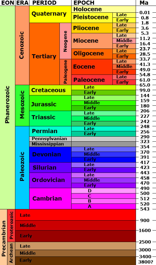
The Geologic Time Scale (or "Geologic Column")
Geologists have examined the history of the earth, and come up with periods
of The time divisions for the Phanerozoic Eon have remained steady for many years. However, you will find differences in the literature on the Precambrian Eon, which represents the period older than 543 million years ago. My approach will be a simplistic one, using the long-accepted divisions. There is plenty of time as you progress in your geologic studies to learn the new divisions. Notice that the right of the chart contains a scale, with Ma at the top. This stands for millions of years (or millions of years ago). Thus, 300 Ma would be 300 million years ago. The next concept to notice is the different divisions at the top. The broadest of these is the Eon, which represents the longest time spans of geologic history. The most recent, representing the last 543 million years, is the Phanerozoic. When referring to older eons, most old texts would have only one other eon, the Precambrian, which represented time back to 4.5 billion years. You may notice that Archean and Proterozoic are also in the Eon category. Most now consider them eons, along with the oldest eon, the Hadean. Each eon is further divided into time periods known as an era. You will need to know the three eras of the Phanerozoic, as they are extremely important to the understanding of geologic history. The Paleozoic Era represents the time from 543 Ma to 248 Ma. The word paleozoic means "ancient life." The Mesozoic Era, probably the most fascinating, represents the earth's history from 248 Ma to 65 Ma. It is also known as the "time of the dinosaurs." The word mesozoic means "middle life." Finally, the Cenozoic Era represents the period from 65 Ma to the present. The term cenozoic means "recent life." Era's are subdivided into time frames known as periods. Period is probably the most commonly known of geologic time divisions. For example, the Mesozoic Era is divided into the Triassic, the Jurassic, and the Cretaceous. If you are a student of dinosaurs, these names will be very familiar to you. Each period is made up of time periods called epochs. The epochs during the Cenozoic have names, whereas the earlier epochs are merely called early, middle, or late. For example, the T-rex, which lived very late in the Cretaceous, would have been said to live in the late Cretaceous period. Not shown in the simplified chart is the next division, called the "age." If you want to see a geologic time scale with the ages defined, click here. For the purposes of this class, you do not need to memorize the geologic time scale. Just be familiar with the material I have put in the text above. Know the names/division times for the eras, but do not be concerned with memorizing the periods, epochs, or ages. Just be familiar with the concept of what they are.
A
geologic map is a special-purpose map made for the purpose of
showing
In order to learn about geologic maps, we will use some web pages from the United States Geological Survey. Please click on this link and read through the material. Be sure to click the links inside this web page, so that you view all the material. You may see some test questions on the basics of geologic maps. If you want to explore further, examine the links below for more maps.
Geologic Map of Wilson County, Kansas (almost 2 Mb, but is a good example) Geologic Maps of Yosemite National Park To view many more, open this Google Image search for "geologic map" Today you will complete an 10 question practice quiz. The link to the quiz will open a new window. You can come back here and check your answers. Do not click the Back button on your browser during the quiz. After the quiz, continue your research project, if necessary. Please review the terms in bold in the text, and ensure you have completed your research work from Tuesday. Today you will take the end of chapter test. Please close all other browser windows, and click on the link below. During the test, do not click on the Back button on your browser. After you have completed the test, you may proceed to Chapter 9 on your next school day. Please return to the introduction page for the link to the next chapter. For More Learning: Return to the Old Earth Ministries Online Geology Curriculum homepage.
|
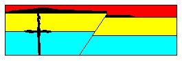 intrusions occur after the sedimentary beds have been deposited. Take
a look at the cross-section at right. There are five geologic events
depicted. There are three sedimentary layers, one igneous intrusion,
and one fault line. Study the cross-section for a minute. What
is the sequence of events for this cross-section? Come up with your
sequence, and then keep reading.
intrusions occur after the sedimentary beds have been deposited. Take
a look at the cross-section at right. There are five geologic events
depicted. There are three sedimentary layers, one igneous intrusion,
and one fault line. Study the cross-section for a minute. What
is the sequence of events for this cross-section? Come up with your
sequence, and then keep reading.