One of the most used means of tracking ancient continents is through studying cratons. A craton (Greek: κράτος kratos "strength") is an old and stable part of the continental crust. Having often survived cycles of merging and rifting of continents, cratons are generally found in the interiors of tectonic plates. They are characteristically composed of ancient crystalline basement rock, which may be covered by younger sedimentary rock. They have a thick crust and deep lithospheric roots that extend as much as a few hundred kilometers into the Earth's mantle.
The term craton is used to distinguish the stable portion of the continental crust from regions that are more geologically active and unstable. Cratons can be described as shields, in which the basement rock crops out at the surface, and platforms, in which the basement is overlain by sediments and sedimentary rock.
Supercontinents During the Precambrian
Vaalbara
Vaalbara
is theorized to be Earth's first supercontinent,
beginning its formation about
3.6 Ga (billion years ago), completing its
formation by about 3.1 Ga and breaking up by 2.5 Ga. The name
Vaalbara is derived from
the South African
Kaapvaal craton and the
West Australian
Pilbara craton. These
cratons were combined
during the time of the Vaalbara supercontinent.
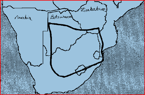
Kaapvaal Craton of South Africa (above) and Pilbara Craton of
Australia (Below). (Picture
Sources)
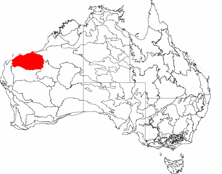
Evidence for Vaalbara is in the similarities in sedimentary sequences on both cratons. Geochronological and paleomagnetic studies between the Kaapvaal and Pilbara cratons show evidence of them having been combined. The structural sequence similarities of the greenstone and gneiss belts are two more pieces of evidence. (These greenstone belts are now found at the margins of the Superior craton of Canada, and across the cratons of the former Gondwana and Laurasia continents.) The subsequent drift paths of the Kaapvaal and Pilbara cratons after 2.8 Bya gives further evidence that they were once connected.
Kenorland
Kenorland is believed to have formed during the Neoarchaean Era ~2.7 billion years ago (2.7 Ga) by the accretion of Neoarchaean cratons and the formation of new continental crust. Kenorland comprised what later became Laurentia (the core of today's North America and Greenland), Baltica (today's Scandinavia and Baltic), Western Australia and Kalahari. Swarms of volcanic dikes and their paleomagnetic orientation as well as the existence of similar stratigraphic sequences permit this reconstruction. The core of Kenorland, the Baltic/Fennoscandian Shield, traces its origins back to over 3.1 Ga. The Yilgarn Craton (present-day Western Australia) contains zircon crystals in its crust that date back to 4.4 Ga.
Paleomagnetic studies show Kenorland was in generally low latitudes until tectonic magma-plume rifting began to occur between 2.48 Ga and 2.45 Ga. The Kola and Karelia cratons began to drift apart ~2.45 Ga, and by 2.4 Ga the Kola craton was located at ~15 degrees latitude and the Karelia craton was located at ~30 degrees latitude. Paleomagnetic evidence shows that at 2.45 Ga the Yilgarn craton (now the bulk of Western Australia) was not connected to Fennoscandia-Laurentia and was located at ~70 degrees latitude.
This implies that at 2.45 Ga there was no longer a supercontinent and by 2.4 Ga an ocean existed between the Kola and Karelia cratons. The breakup of Kenorland was contemporary with the Huronian glaciation which persisted for up to 60 million years. The banded iron formations (BIF) show their greatest extent at this period, thus indicating a massive increase in oxygen build-up from an estimated 0.1% of the atmosphere to 1%. The rise in oxygen levels caused the virtual disappearance of the greenhouse gas methane (oxidized into carbon dioxide and water).
The simultaneous breakup of Kenorland generally increased continental rainfall everywhere, thus increasing erosion and further reducing the other greenhouse gas carbon dioxide. With the reduction in greenhouse gases, and with solar output being less than 85% its current power, this led to a runaway Snowball Earth scenario, where average temperatures planet-wide plummeted to below freezing. Despite the anoxia indicated by the BIF, photosynthesis continued, stabilizing climates at new levels during the second part of the Proterozoic Era.
Columbia
Columbia was a supercontinent that was thought to have existed approximately 1.8 to 1.5 billion years (Ga) ago in the Paleoproterozoic Era. It consisted of the proto-cratons that made up the former continents of Laurentia, Baltica, Ukrainian Shield, Amazonia, Australia, and possibly Siberia, North China and Kalaharia as well. The existence of Columbia is based upon paleomagnetic data.
Columbia is estimated to have been about 12,900 kilometres (8,000 miles) from North to South, and about 4,800 km (3,000 miles) across at its widest part. The east coast of India was attached to western North America, with southern Australia against western Canada. Most of South America rotated so that the western edge of modern-day Brazil lined up with eastern North America, forming a continental margin that extended into the southern edge of Scandinavia.
Columbia began to fragment about 1.6 Ga ago, associated with continental rifting along the western margin of Laurentia (Belt-Purcell Supergroup), eastern India (Mahanadi and the Godavari), southern margin of Baltica (Telemark Supergroup), southeastern margin of Siberia (Riphean aulacogens), northwestern margin of South Africa (Kalahari Copper Belt), and northern margin of the North China Block (Zhaertai-Bayan Obo Belt).
The fragmentation corresponded with widespread anorogenic magmatic activity, forming anorthosite-mangerite-charnockite-granite (AMCG) suites in North America, Baltica, Amazonia and North China, and continued until the final breakup of the supercontinent at about 1.3-1.2 Ga, marked by the emplacement of the 1.27 Ga Mackenzie and 1.24 Ga Sudbury mafic dike swarms in North America.
Rodinia
Rodinia (from the Russian родина, "rodina", meaning "motherland") was a supercontinent that contained most or all of Earth's landmass. Rodinia existed between 1100 and 750 million years ago, in the Neoproterozoic era. Rodinia's landmass was probably centered south of the equator. Most reconstructions show Rodinia's core was formed by the North American craton (the later paleocontinent of Laurentia), surrounded in the southeast with the East European craton (the later paleocontinent of Baltica), the Amazonian craton ("Amazonia") and the West African craton; in the south with the Rio de la Plata and São Francisco cratons; in the southwest with the Congo and Kalahari cratons; and in the northeast with Australia, India and eastern Antarctica. In contrast to Rodinia's formation, the movements of continental masses during and since its breakup are fairly well understood.
Rodinia was surrounded by the superocean geologists refer to as Mirovia (from Russian мировой, mirovoy, meaning "global").
Influence on paleoclimate and life
Unlike later supercontinents, Rodinia itself was entirely barren. It existed before life colonized dry land, and, since it predated the formation of the ozone layer, it was too exposed to ultraviolet sunlight for any organism to inhabit it. Nevertheless, its existence did significantly influence the marine life of its time.
In the Cryogenian period the Earth experienced large glaciations, and temperatures were at least as cool as today. Substantial areas of Rodinia may have been covered by glaciers or the southern polar ice cap.
Low temperatures may have been exaggerated during the early stages of continental rifting. Geothermal heating peaks in crust about to be rifted; and since warmer rocks are less dense, the crustal rocks rise up relative to their surroundings. This rising creates areas of higher altitude, where the air is cooler and ice is less likely to melt with changes in season, and it may explain the evidence of abundant glaciation in the Ediacaran period.
The eventual rifting of the continents created new oceans, and seafloor spreading, which produces warmer, less-dense oceanic lithosphere. Due to its lower density, hot oceanic lithosphere will not lie as deep as old, cool oceanic lithosphere. In periods with relatively large areas of new lithosphere, the ocean floors come up, causing the eustatic sea level to rise. The result was a greater number of shallower seas.
The increased evaporation from the larger water area of the oceans may have increased rainfall, which, in turn, increased the weathering of exposed rock. This increased rainfall may have reduced greenhouse gas levels to below the threshold required to trigger the period of extreme glaciation known as Snowball Earth.
Increased volcanic activity also introduced into the marine environment biologically active nutrients, which may have played an important role in the development of the earliest animals.
The extreme cooling of the global climate around 700 million years ago (the so called Snowball Earth of the Cryogenian period) and the rapid evolution of primitive life during the subsequent Ediacaran and Cambrian periods are often thought to have been triggered by the breaking up of Rodinia. (For Christians who do not believe in evolution (i.e. Progressive Creationists), the planet at this time was ready for God to introduce many new life forms.)
End of Reading
Return to the Old Earth Ministries Online Earth History Curriculum homepage
Adapted from Wikipedia pages