Section 1: Earth's Basic Composition
The earth is made up of several layers. The atmosphere of the earth is primarily studied by the branch of science known as climatology, or meteorology. The layers of the earth's solid matter are studied by geologists. Many geological features are caused by climatology, due to weathering of the rocks of the earth.
The two main regions of the earth's surface are continents and ocean basins. Continents are large landmasses, composed mostly of granite type rocks, but also composed of sedimentary and metamorphic rocks. Ocean basins are the low-lying portion of the earth's surface which lies between the continental landmasses.
The uppermost surface of the earth is called the crust. There are two main types of crust. Continental crust, which forms the exposed land masses of earth, is approximately 10 to 22 miles thick (16 to 35 kilometers). The other type of crust is known as oceanic crust. This type of crust is only 5 to 10 miles thick (8 to 16 kilometers). The primary difference between these crusts is the mineral composition. The density of oceanic crust causes it to sink in relation to continental crusts, which plays an important role in plate tectonics.
The shape and
form of the earth's surface, including elevation differences, is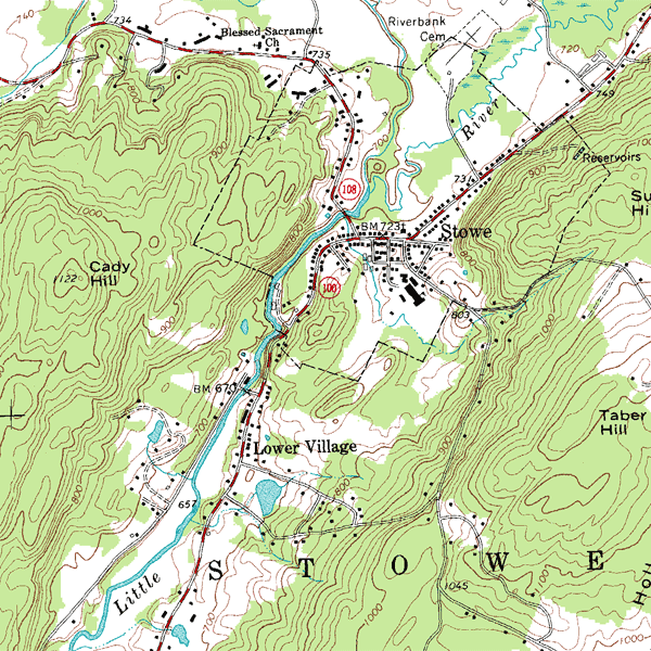 known as topography. Topography can be studied through
the use of a topographic map (click the map for a larger view). Each
line on a topographic map represents a change of elevation. The scale
of each line can usually be found in the map legend. Geologists
receive training in order to make topographic maps. For additional
study on topographic maps,
click
here.
known as topography. Topography can be studied through
the use of a topographic map (click the map for a larger view). Each
line on a topographic map represents a change of elevation. The scale
of each line can usually be found in the map legend. Geologists
receive training in order to make topographic maps. For additional
study on topographic maps,
click
here.
Continents
There are several major features of continents. Typically, continents have three parts. The first part is known as a shield. A shield is a regional area with low relief (little elevation change). The elevation of a shield is typically within a few hundred yards of sea level. For additional study of shields, click here.
Another part of continents is the stable platform. This feature is characterized by a covering of sedimentary rocks. It is called stable because it has largely remained unchanged for many millions of years. The stable platforms have never been subjected to uplifting tectonic forces.
The third part of
continents is known as folded mountain belts. These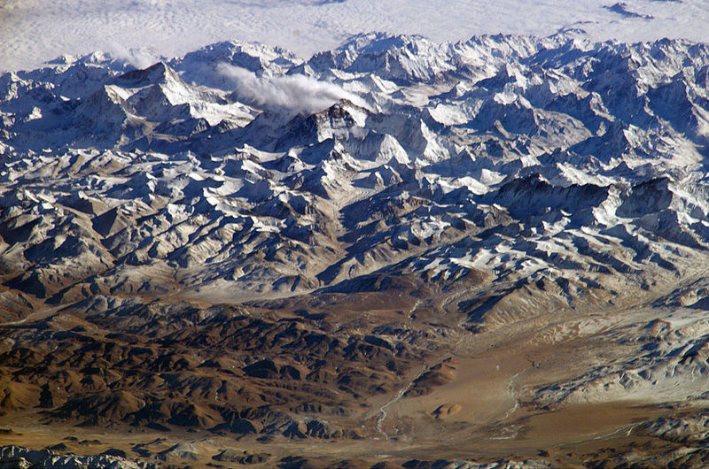 mountains normally occur along the margins, although they can also form on
the continents interior. Typically, except for a few volcanoes,
mountains form in belts, or ranges, because of the collision of two tectonic
plates. The image at right shows a picture of the Himalayan Mountains
as seen from the International Space Station (click image for a larger
view). These mountain ranges can be thousands of miles long, and
hundreds of miles wide. Because of their formation from the collision
of tectonic plates, they are great evidence that the earth's crust is in
motion.
mountains normally occur along the margins, although they can also form on
the continents interior. Typically, except for a few volcanoes,
mountains form in belts, or ranges, because of the collision of two tectonic
plates. The image at right shows a picture of the Himalayan Mountains
as seen from the International Space Station (click image for a larger
view). These mountain ranges can be thousands of miles long, and
hundreds of miles wide. Because of their formation from the collision
of tectonic plates, they are great evidence that the earth's crust is in
motion.
It is important to note that although other planets have mountains, they do not have mountain ranges. This is because they do not have tectonic plates which move about the surface of the earth. For additional study, see mountain range.
Ocean Basins
Despite what you
might think, there is a lot of different topographic features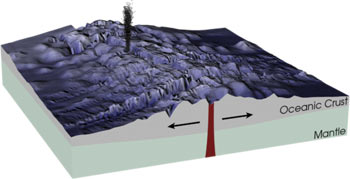 underneath the world's oceans. One of the most important features is
the oceanic ridge. The ridge is a broad, fractured
uplift in the center of the oceans, and it can be as wide as 870 miles
(1,400 kilometers). At the center of this ridge is the rift
valley, where new volcanic material is being expelled from the
earth's mantle. Because of the volcanic origin of the oceanic crust,
it is mostly composed of a dense rock known as basalt.
underneath the world's oceans. One of the most important features is
the oceanic ridge. The ridge is a broad, fractured
uplift in the center of the oceans, and it can be as wide as 870 miles
(1,400 kilometers). At the center of this ridge is the rift
valley, where new volcanic material is being expelled from the
earth's mantle. Because of the volcanic origin of the oceanic crust,
it is mostly composed of a dense rock known as basalt.
As the new material
is expelled, the oceanic crust grows, and it is pushed away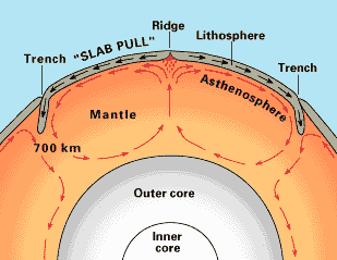 from the ridge by convection currents in the mantle. This is
known as seafloor spreading (see an
animation of seafloor spreading). The further away from the ridge
you go, the older the rocks of the oceanic crust are. Most of
the current oceanic crust is less than 150 million years old, whereas the
age of the continental shields are typically around 700 million years old.
To learn more, see
seafloor spreading.
from the ridge by convection currents in the mantle. This is
known as seafloor spreading (see an
animation of seafloor spreading). The further away from the ridge
you go, the older the rocks of the oceanic crust are. Most of
the current oceanic crust is less than 150 million years old, whereas the
age of the continental shields are typically around 700 million years old.
To learn more, see
seafloor spreading.
Another feature of the sea floor is called the abyssal floor. This is the vast, broad areas that are relatively smooth, and they are typically about 2,300 feet deep (3,000 meters). The abyssal floor is further divided into to parts. The abyssal hills are small hills rising several hundred meters above the surrounding ocean floor. They are actually the most prevalent landform on earth, because the cover more than 80 percent of the Pacific Ocean floor. Closer to the continents is an area known as the abyssal plains, which is composed mostly of eroded material from the continent. For more learning, see abyssal plains.
Seamounts are another prominent feature. These are isolated peaks of volcanoes which are underwater. Sometimes they can rise above sea level, such as the Hawaiian island chain. Seamounts which rise above the surface are no longer called seamounts, and instead are referred to as islands. To learn more, see seamount.
One of the most fascinating features of the ocean floor are the trenches. A trench is were the oceanic crust is diving beneath another section of crust. The Mariana Trench is probably the most well known, as it is the deepest point in the world's oceans (and therefore the deepest point on the earth's crust). It has a maximum depth of 35,798 feet, or 10,911 meters. For more, see Mariana Trench.
The final feature of the ocean floor that we will consider is the continental margins. A continental margin is an area of transition between a continental mass and an ocean basin. The submerged part of the continent is called a continental shelf. Technically, it is part of the continent, even though it is underwater. This is because it moves as a whole with the continental land mass. For more, see continental shelf.
The continental
shelf can be up to 930 miles wide (1,500 kilometers), as is the case with![]() the Siberian shelf. The shelf itself slopes away from the continent.
This long slope is known as the continental slope. This
area is not perfectly flat. It is cut in many places by underwater
currents, or rivers, which form submarine canyons. These
can be quite large, and extend for hundreds of miles. For more, see
submarine canyons.
the Siberian shelf. The shelf itself slopes away from the continent.
This long slope is known as the continental slope. This
area is not perfectly flat. It is cut in many places by underwater
currents, or rivers, which form submarine canyons. These
can be quite large, and extend for hundreds of miles. For more, see
submarine canyons.
Section 2: Sedimentary Rock
The study of the earth's history centers upon the study of sedimentary rock layers. These rocks contain the fossils that paleontologists study to examine ancient life forms. These fossils are used in Biostratigraphy to date the relative ages of the rock layers. Thus it is imperative that the geology student understand the basic processes involving sedimentary rock.
The rock material that comprises sedimentary rocks starts out as parts of other rocks, before it is weathered away, and carried by some transportation system, either wind or water, to the point where it is deposited, and then it finally solidifies (lithifies) into a sedimentary rock. The deposition environment includes the physical, chemical, and biological conditions that are present at the location of deposition. Each environment produces rocks which are characteristic of that environment. For example, beaches produce sandstones, but so does wind-blown sand, which produces a desert sandstone.
Finally, compaction and cementation presses the grains together, and "glues" them, making them into rocks. Compaction occurs because the layers of rock on top of each other are compressing the bottom layers, squeezing out moisture, and allowing them to cement together. The cement is commonly calcite, quartz, or limonite.
In geology and related fields, a stratum (plural: strata) is a layer of rock or soil with internally consistent characteristics that distinguishes it from contiguous layers. Each layer is generally one of a number of parallel layers that lie one upon another, laid down by natural forces. They may extend over hundreds of thousands of square kilometers of the Earth's surface. Strata are typically seen as bands of different colored or differently structured material exposed in cliffs, road cuts, quarries, and river banks. Individual bands may vary in thickness from a few millimeters to a kilometer or more. Each band represents a specific mode of deposition—river silt, beach sand, coal swamp, sand dune, lava bed, etc.
Geologists study rock strata and categorize them by the material in the beds. Each distinct layer is usually assigned to a "formation" name usually based on a town, river, mountain, or region where the formation is exposed and available for study. For example, the Burgess Shale is a thick exposure of dark, occasionally fossiliferous, shale exposed high in the Canadian Rockies near Burgess Pass. Slight distinctions in material in a formation may be described as "members" or sometimes "beds." Formations are collected into "groups." Groups may be collected into "supergroups."
More on Formations
A formation or geological formation is the fundamental unit of lithostratigraphy. A formation consists of a certain number of rock strata that have a comparable lithology, facies or other similar properties. Formations are not defined on the thickness of the rock strata they consist of and the thickness of different formations can therefore vary widely.
The concept of formally defined layers or strata is central to the geologic discipline of stratigraphy. A formation can be divided into members and are themselves grouped together in groups.
Usefulness of formations
Formations allow geologists to correlate geologic strata across wide distances between outcrops and exposures of rock strata. An outcrop is an exposure of rock deposits at the surface of the Earth.
Formations were initially described to be the essential geologic time markers based on relative ages and the law of superposition. The divisions of the geological time scale were the formations described and put in chronological order by the geologists and stratigraphers of the 17th and 18th centuries.
Modern revision of the geologic sciences has restricted Formations to lithologies, because lithological units are formed by depositional environments, some of which may persist for hundreds of millions of years and will transgress chronostratigraphic intervals or fossil-based methods of correlating rocks. For example, the Hammersley Basin is a Proterozoic sedimentary basin where up to 1200 million years of sedimentation is preserved within the intact sedimentary stratigraphy, with up to 300 million years represented by a single lithological unit of banded iron formation and shale.
Geologic formations are usually sedimentary rock layers, but may also be metamorphic rocks and volcanic flows. Igneous intrusive rocks are generally not divided into Formations.
End of Reading
Return to the Old Earth Ministries Online Earth History Curriculum homepage.
Text © Old Earth Ministries