Old Earth Ministries Online Earth History Curriculum

Presented by Old Earth Ministries (We Believe in an Old Earth...and God!)

This curriculum is presented free of charge for use by homeschooling families.

NOTE:  If you found this page through a search engine, please visit the intro page first.


Chapter 13 - The Neogene Period

Lesson 65: The Grand Canyon, Part 1


      The Grand Canyon has fascinated visitors for many years, and has drawn the attention of many Christians, as they wonder how this geologic feature was made, and if it had anything to do with Noah's Flood.  In this lesson, we will examine the making of the rocks that comprise the canyon, and in the next lesson, we will examine how the canyon was formed.

     The Grand Canyon is a steep-sided canyon carved by the Colorado River in the United States in the state of Arizona. It is largely contained within the Grand Canyon National Park, one of the first national parks in the United States. President Theodore Roosevelt was a major proponent of preservation of the Grand Canyon area, and visited it on numerous occasions to hunt and enjoy the scenery.


Chapter 13: The Neogene Period


 Lesson 62 - Neogene Overview

 Lesson 63 - Miocene Epoch

 Lesson 64 - Pliocene Epoch

 Lesson 65 - The Grand Canyon, Part 1

 Lesson 66 - The Grand Canyon, Part 2 

 Test 

Grand Canyon

Click picture to enlarge (Picture Source)

     The Grand Canyon is 277 miles (446 km) long, up to 18 miles (29 km) wide and attains a depth of over a mile (1.83 km) (6000 feet). Nearly two billion years of the Earth's
Grand Canyon
Grand Canyon as seen from space (Picture Source)
 geological history have been exposed as the Colorado River and its tributaries cut their channels through layer after layer of rock while the Colorado Plateau was uplifted. While the specific geologic processes and timing that formed the Grand Canyon are the subject of debate by geologists, recent evidence suggests the Colorado River established its course through the canyon at least 17 million years ago. Since that time, the Colorado River continued to erode and form the canyon to the point we see it at today.

     The geology of the Grand Canyon area exposes one of the most complete and studied sequences of rock on the planet. The nearly 40 major sedimentary rock layers exposed in
Stratigraphy of the Grand Canyon
Stratigraphy of the Grand Canyon.  Clicking the picture will open a new window that you can refer to as you read about the rock units below.
 the Grand Canyon and in the Grand Canyon National Park area range in age from about 200 million to nearly 2 billion years old. Most were deposited in warm, shallow seas and near ancient, long-gone sea shores in western North America. Both marine and terrestrial sediments are represented, including fossilized sand dunes from an extinct desert. There are at least 14 known unconformities in the geologic record found in the Grand Canyon area.

     Uplift of the region started about 75 million years ago in the Laramide orogeny; a mountain-building event that is largely responsible for creating the Rocky Mountains to the east. In total the Colorado Plateau was uplifted an estimated 2 miles (3.2 km). The adjacent Basin and Range province to the west started to form about 18 million years ago as the result of crustal stretching. A drainage system that flowed through what is today the eastern Grand Canyon emptied into the now lower Basin and Range province. Opening of the Gulf of California around 6 million years ago enabled a large river to cut its way northeast from the gulf. The new river captured the older drainage to form the ancestral Colorado River, which in turn started to form the Grand Canyon.

     Wetter climates brought upon by ice ages starting 2 million years ago greatly increased excavation of the Grand Canyon, which was nearly as deep as it is now by 1.2 million years ago. Volcanic activity deposited lava over the area 1.8 million to 500,000 years ago. At least 13 lava dams blocked the Colorado River, forming lakes that were up to 2,000 feet (610 m) deep. The end of the ice age and subsequent human activity has greatly reduced the ability of the Colorado River to excavate the canyon. Dams in particular have upset patterns of sediment transport and deposition. Controlled floods from Glen Canyon Dam upstream have been conducted to see if they have a restorative effect. Earthquakes and mass wasting erosive events still affect the region.


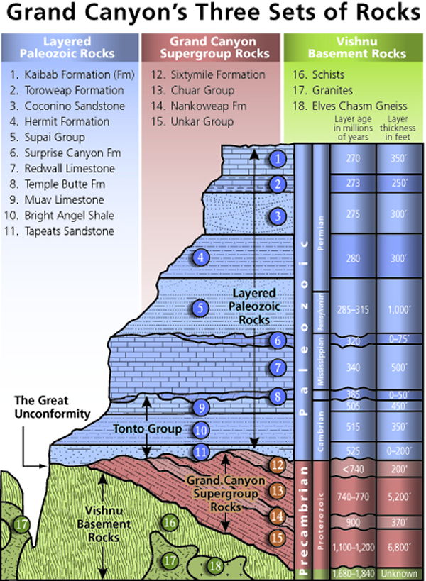
Metamorphic and Igneous Basement


     The Granite Gorge Metamorphic Suite consists of the metasedimentary Vishnu Schist and the metavolcanic Brahma and Rama Schists. All were formed 1.75 billion to 1.73 billion years ago in Precambrian time when thousands of feet of volcanic ash, mud, sand, and silt were laid down in a shallow backarc basin similar to the modern Sea of Japan. The basin was between an early form of North America called Laurentia and an orogenic belt of mountains and volcanoes in an island arc similar to modern Japan.

     From 1.8 to 1.6 billion years ago at least two island arcs collided with the proto-North
Vishnu Basement
Metamorphic Basement Rocks in the Grand Canyon.
 American continent. This process of plate tectonics compressed and grafted these marine sediments onto Laurentia and uplifted them out of the sea. Later, these rocks were buried 12 miles (19 km) under the surface and pressure-cooked into metamorphic rock. 
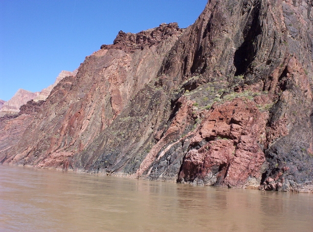
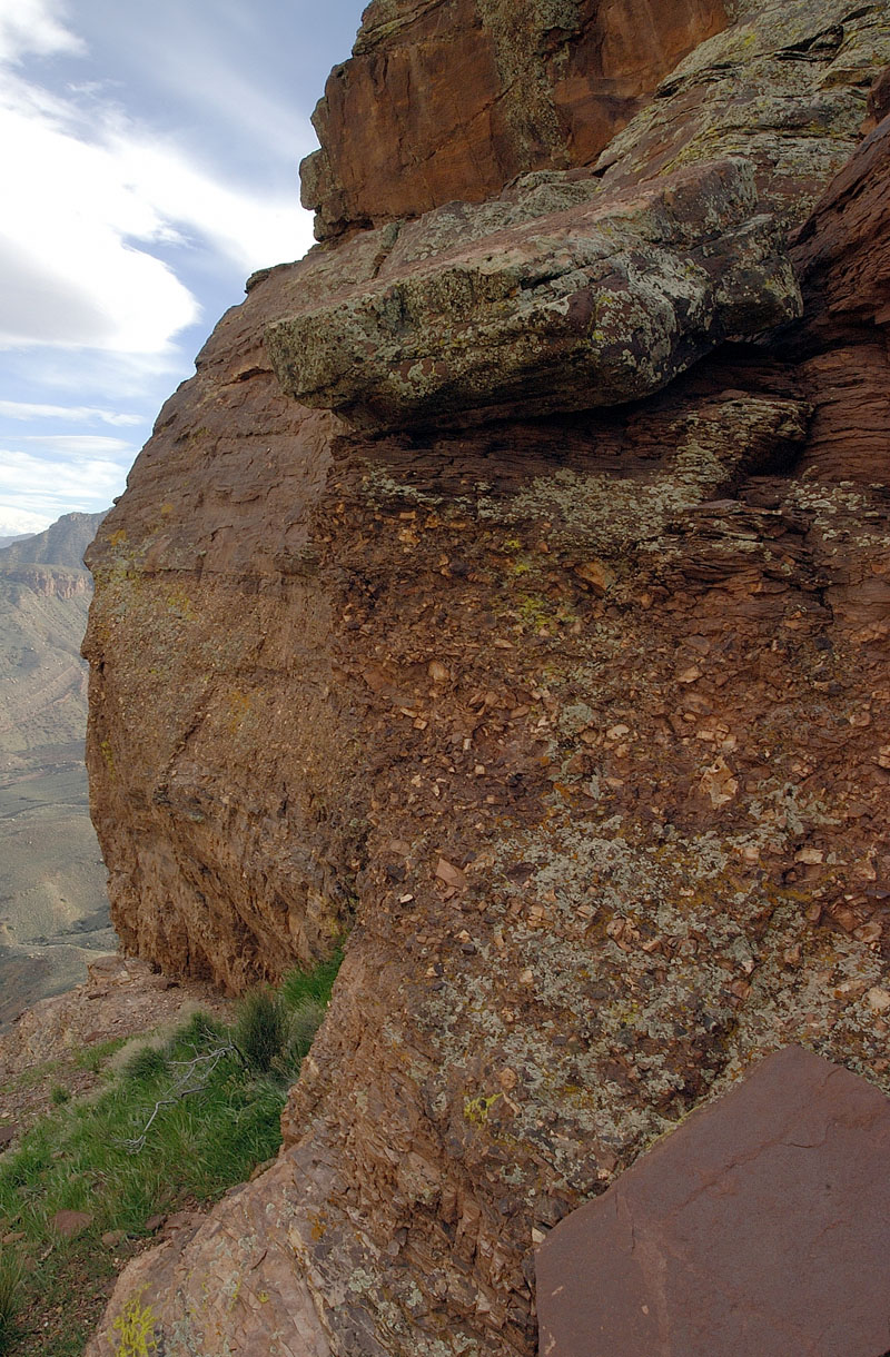
This is the resistant rock now exposed at the bottom of the canyon in the Inner Gorge. No identifiable fossils have been found in the Suite, but lenses of marble now seen in these units were likely derived from colonies of primitive algae.

     As the volcanic islands collided with the mainland around 1.7 billion years ago, blobs of magma rose from the subduction zone and intruded the Granite Gorge Metamorphic Suite. These plutons slowly cooled to form the Zoroaster Granite; part of which would later be metamorphosed into gneiss. This rock unit can be seen as light-colored bands in the darker garnet-studded Vishnu Schist (see 1b in Figure 1). The intrusion of the granite occurred in three phases: two during the initial Vishnu metamorphism period, and a third around 1.4 billion years ago. The third phase was accompanied by large-scale faulting, particularly along north—south faults, leading to a partial rifting of the continent. The collision expanded the continent from the WyomingColorado border into Mexico and almost doubled the crust's thickness in the Grand Canyon region. Part of this thickening created the 5-to-6-mile (8 to 10 km) high ancestral Mazatzal Mountains.

     Subsequent erosion lasting 300 million years stripped much of the exposed sediments and the mountains away. This reduced the very high mountains to small hills a few tens to hundreds of feet (tens of meters) high. Geologist John Wesley Powell called this major gap in the geologic record, which is also seen in other parts of the world, the Great Unconformity. Other sediments may have been added but, if they ever existed, were completely removed by erosion. Such gaps in the geologic record are called unconformities by geologists. The Great Unconformity is one of the best examples of an exposed nonconformity, which is a type of unconformity that has bedded rock units above igneous or metamorphic rocks.


Deposition of Sedimentary Layers

Grand Canyon Supergroup


     In late Precambrian time, extension from a large tectonic plate or smaller plates moving away from Laurentia thinned its continental crust, forming large rift basins that would ultimately fail to split the continent. Eventually, this sunken region of Laurentia was flooded with a shallow seaway that extended from at least present-day Lake Superior to Glacier National Park in Montana to the Grand Canyon and the Uinta Mountains. The resulting Grand Canyon Supergroup of sedimentary units formed by this shallow seaway is composed of nine varied geologic formations that were laid down from 1.2 billion and 740 million years ago in this sea. 
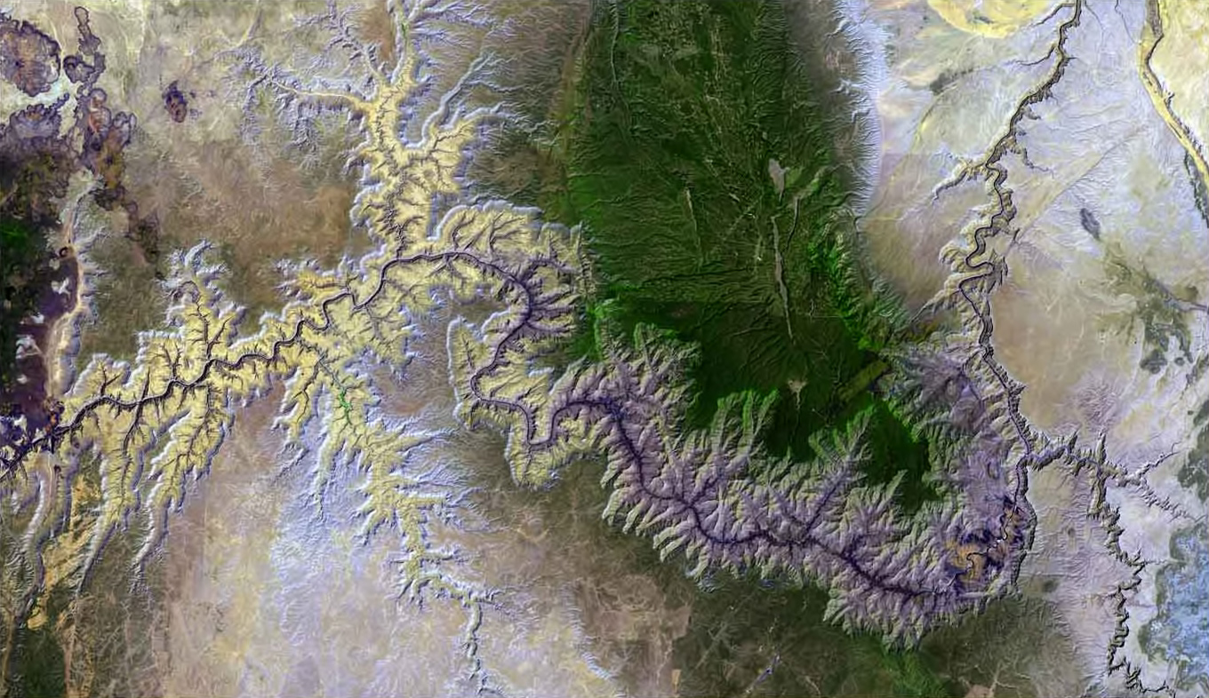
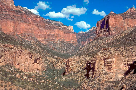
Good exposures of the supergroup can be seen in eastern Grand Canyon in the Inner Gorge and from Desert View, Lipan Point and Moran point.

     The oldest section of the supergroup is the Unkar Group.  It was laid down in an offshore environment. The first formation to be laid down in the Unkar Group was the Bass Limestone. The Bass Limestone was deposited in a shallow sea near the coast as a mix of limestone, sandstone, and shale. It is 120 to 340 feet (37 to 100 m) thick and grayish in color. Averaging 1250 million years old, this is the oldest layer exposed in the 
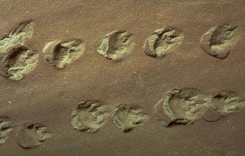
Grand Canyon that contains fossils—stromatolites.  The next layer is the Hakatai Shale.  It is made of thin beds of marginal-marine-derived mudstones, sandstones, and shale that, together, are 445 to 985 feet (136 to 300 m) thick. This formation indicates a short-lived regression (retreat) of the seashore in the area that left mud flats. 
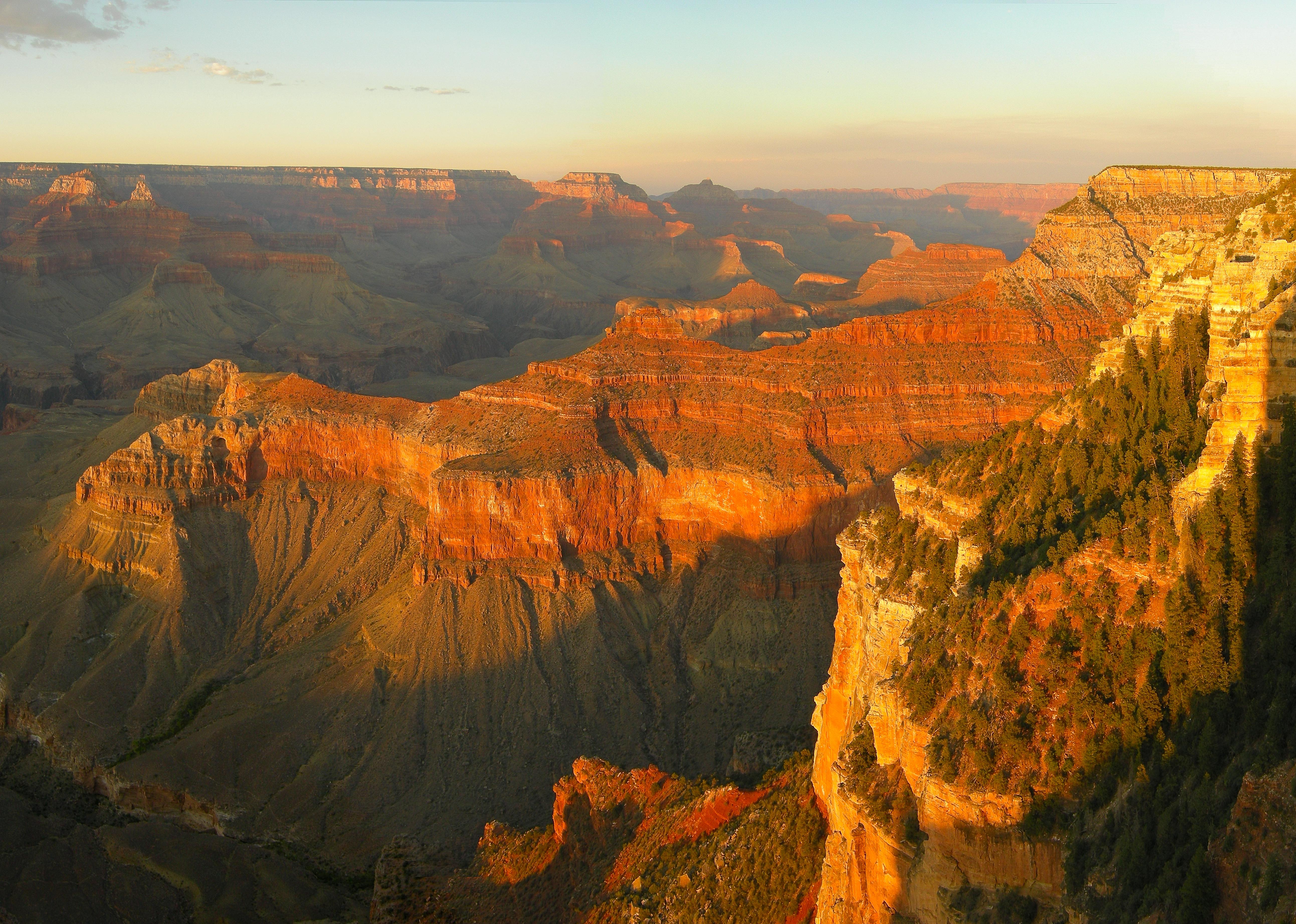
Today it is very bright orange-red and gives the Red Canyon its name. Shinumo Quartzite was a resistant marine sandstone that later formed islands in Cambrian time. Those islands withstood wave action long enough to become re-buried by other sediments in the Cambrian Period. It was later metamorphosed into quartzite. Dox Sandstone is over 3,000 feet (910 m) thick and is made of ocean-derived sandstone with some interbedded shale beds and mudstone. Ripple marks and other features indicate it was close to the shore. Outcrops of this red to orange formation can be seen in the eastern parts of the canyon. Fossils of stromatolites and algae are found in this layer. At 1070 ± 70 million years old, the Cardenas Lava is the youngest formation in the Unkar Group. It is made of layers of dark brown basaltic rocks that flowed as lava up to 1,000 feet (300 m) thick.

     Nankoweap Formation is around 1050 million years old and is not part of a group. This rock unit is made of coarse-grained sandstone, and was deposited in a shallow sea on top of the eroded surface of the Cardenas Lava. The Nankoweap is only exposed in the eastern part of the canyon. A gap in the geologic record, an unconformity, follows the Nankoweap.

     All formations in the Chuar Group were deposited in coastal and shallow sea
Sixtymile Formation
Sixtymile Formation in the Grand Canyon.
 environments about 1000 to 700 million years ago.

bullet

Galeros Formation is a mainly greenish formation composed of interbedded sandstone, limestone, and shale with some shale. It ranges in color from red to purple. Fossilized stromatolites are found in the Galeros.

bullet

Kwagunt Formation consists of black shale and red to purple mudstone with some limestone. Isolated pockets of reddish sandstone are also found around Carbon Butte. Stromatolites are found in this layer.

bullet

Sixtymile Formation is made of tan-colored sandstone with some small sections of shale.

     About 800 million years ago the supergroup was tilted 15° and block faulted in the Grand Canyon Orogeny. Some of the block units moved down and others moved up while fault movement created north—south-trending fault-block mountain ranges. About 100 million years of erosion took place that washed most of the Chuar Group away along with part of the Unkar Group (exposing the Shinumo Quartzite as previously explained). The mountain ranges were reduced to hills, and in some places, the whole 12,000 feet (3,700 m) of the supergroup were removed entirely, exposing the basement rocks below. Any rocks that were deposited on top of the Grand Canyon Supergroup in the Precambrian were completely removed. This created a major unconformity that represents 460 million years of lost geologic history in the area.


Tonto Group


     During the Paleozoic era, the western part of what would become North America was near the equator and on a passive margin. The Cambrian Explosion of life took place over about 15 million years in this part of the world. Climate was warm and invertebrates, such as the trilobites, were abundant. An ocean started to return to the Grand Canyon area from the west about 550 million years ago. As its shoreline moved east, the ocean began to concurrently deposit the three formations of the Tonto Group.

bullet

Tapeats Sandstone averages 525 million years old and is made of cliff-derived medium- to coarse-grained sand and conglomerate that was deposited on an ancient shore. Ripple marks are common in the upper members of this dark brown thin-bedded layer. Fossils and imprint trails of trilobites and brachiopods have also been found in the Tapeats. Today it is a cliff-former that is 100 to 325 feet (30 to 100 m) thick.

bullet

Bright Angel Shale averages 515 million years old and is made of mudstone-derived shale that is interbeded with small sections of sandstone and shaly limestone with a few thin beds of dolomite. It was mostly deposited as mud just offshore and contains brachiopod, trilobite, and worm fossils. The color of this formation is mostly various shades of green with some brownish-tan to gray parts. It is a slope-former and is 270 to 450 feet (82 to 140 m) thick. Glauconite is responsible for the green coloration of the Bright Angel.

bullet

Muav Limestone averages 505 million years old and is made of gray, thin-bedded limestone that was deposited farther offshore from calcium carbonate precipitates. It is fossil poor yet trilobites and brachiopods have been found in it. The western part of the canyon has a much thicker sequence of Muav than the eastern part. The Muav is a cliff-former, 136 to 827 feet (41 to 252 m) thick.

     These three formations were laid down over a period of 30 million years from early to
Tonto Group
Tonto Group Rocks (Picture linked from http://jan.ucc.nau.edu/~rcb7/GreatUnc3.Jpg)
 middle Cambrian time. Trilobites followed by brachiopods are the most commonly reported fossils in this group but well-preserved fossils are relatively rare. We know that the shoreline was transgressing (advancing onto land) because finer grade material was deposited on top of coarser-grained sediment. Today, the Tonto Group makes up the Tonto Platform seen above and following the Colorado River; the Tapeats Sandstone and Muav Limestone form the platform's cliffs and the Bright Angel Shale forms its slopes. Unlike the Proterozoic units below it, the Tonto Group's beds basically lie in their original horizontal position. The Bright Angel Shale in the group forms an aquiclude (barrier to groundwater seeping down), and thus collects and directs water through the overlying Muav Limestone to feed springs in the Inner Gorge.


Temple Butte, Redwall, and Surprise Canyon


     The next two periods of geologic history, the Ordovician and the Silurian, are missing from the Grand Canyon sequence. Geologists do not know if sediments were deposited in these periods and were later removed by erosion or if they were never deposited in the first place. Either way, this break in the geologic history of the area spans about 165 million years. A type of unconformity called a disconformity was formed. Disconformities show erosional features such as valleys, hills and cliffs that are later covered by younger sediments.

bullet

Temple Butte Limestone: Geologists do know that deep channels were carved on the top of the Muav Limestone during this time. Streams were the likely cause but marine scour may be to blame. Either way, these depressions were filled with freshwater limestone about 385 million years ago in the Middle Devonian in a formation that geologists call the Temple Butte Limestone. Marble Canyon in the eastern part of the park displays these filled purplish-colored channels well. Temple Butte Limestone is a cliff-former in the western part of the park where it is gray to cream-colored dolomite. Fossils of animals with backbones are found in this formation; bony plates from freshwater fish in the eastern part and numerous marine fish fossils in the western part. Temple Butte is 100 to 450 feet (30 to 140 m) thick; thinner near Grand Canyon Village and thicker in western Grand Canyon. An unconformity representing 40 to 50 million years of lost geologic history marks the top of this formation.

bullet

Redwall Limestone:  The next formation in the Grand Canyon geologic column is
Redwall Limestone
Redwall Limestone (red layers).  The sandstone in the foreground is the Tapeats.
 the cliff-forming Redwall Limestone, which is 400 to 800 feet (120 to 240 m) thick. Redwall is composed of thick-bedded, dark brown to bluish gray limestone and dolomite with white chert nodules mixed in. It was laid down in a retreating shallow tropical sea near the equator during 40 million years of the early to middle Mississippian. Many fossilized crinoids, brachiopods, bryozoans, horn corals, nautiloids, and sponges, along with other marine organisms such as large and complex trilobites have been found in the Redwall. In late Mississippian time, the Grand Canyon region was slowly uplifted and the Redwall was partly eroded away. A Karst topography consisting of caves, sinkholes, and subterrainian river channels resulted but were later filled with more limestone. The exposed surface of Redwall gets its characteristic color from rainwater dripping from the iron-rich redbeds of the Supai and Hermit shale that lie above.

bullet

Surprise Canyon Formation:   This formation is a sedimentary layer of purplish-red shale that was laid down in discontinuous beds of sand and lime above the Redwall. It was created in very late Mississippian and possibly in very earliest Pennsylvanian time as the land subsided and tidal estuaries filled river valleys with sediment. This formation only exists in isolated lenses that are 50 to 400 feet (15 to 120 m) thick. Surprise Canyon was unknown to science until 1973 and can only be reached by helicopter. Fossil logs, other plant material and marine shells are found in this formation. An unconformity marks the top of the Surprise Canyon Formation and in most places this unconformity has entirely removed the Surprise Canyon and exposed the underlying Redwall.

Supai Group


     An unconformity of 15 to 20 million years separates the Supai Group from the previously deposited Redwall Formation. Supai Group was deposited in late Mississippian, through the Pennsylvanian and into the early Permian time, some 320 million to 270 million years ago. Both marine and non-marine deposits of mud, silt, sand and calcareous sediments were laid down on a broad coastal plain similar to the Texas Gulf Coast of today. Around this time, the Ancestral Rocky Mountains rose in Colorado and New Mexico and streams brought eroded sediment from them to the Grand Canyon area.

     Supai Group formations in the western part of the canyon contain limestone, indicative of a warm, shallow sea, while the eastern part was likely a muddy river delta. This formation consists of red siltstones and shale capped by tan-colored sandstone beds that together reach a thickness of 600 to 700 feet (200 to 200 m). Shale in the early Permian formations in this group were oxidized to a bright red color. Fossils of amphibian footprints, reptiles, and plentiful plant material are found in the eastern part and increasing numbers of marine fossils are found in the western part.

     Formations of the Supai Group are from oldest to youngest (an unconformity is present at the top of each): Watahomigi is a slope-forming gray limestone with some red chert bands, sandstone, and purple siltstone that is 100 to 300 feet (30 to 90 m) thick.  Manakacha is a cliff- and slope-forming pale red sandstone and red shale that averages 300 feet (90 m) thick in Grand Canyon. Wescogame is a ledge- and slope-forming pale red sandstone and siltstone that is 100 to 200 feet (30 to 60 m) thick. Esplanade is a ledge- and cliff-forming pale red sandstone and siltstone that is 200 to 800 feet (60 to 200 m) thick. An unconformity marks the top of the Supai Group.


Hermit, Coconino, Toroweap, and Kaibab

bullet

Hermit Shale:  Like the Supai Group below it, the Permian-aged Hermit Shale was likely deposited on a broad coastal plain. The alternating thin-bedded iron oxide, mud and silt were deposited via freshwater streams in a semiarid environment around 280 million years ago. Fossils of winged insects, cone-bearing plants, and ferns are found in this formation as well as tracks of vertebrate animals. It is a soft, deep red shale and mudstone slope-former that is approximately 100 to 900 feet (30 to 270 m) thick. Slope development will periodically undermine the formations above and car- to house-sized blocks of that rock will cascade down onto the Tonto Platform. An unconformity marks the top of this formation.

bullet

Coconino Sandstone formed about 275 million years ago as the area dried out and sand dunes made of quartz sand invaded a growing desert. Some Coconino fills deepCoconino Sandstone Footprints mudcracks in the underlying Hermit Shale and the desert that created the Coconino lasted for 5 to 10 million years. Today, the Coconino is a 57 to 600 feet (17 to 180 m) thick golden white to cream-colored cliff-former near the canyon's rim. Eolian (wind-created) cross bedding patterns of the frosted, well-sorted and rounded sand can be seen in its fossilized sand dunes. Also fossilized are tracks from lizard-like creatures and what look like tracks from millipedes and scorpions. An unconformity marks the top of this formation.  The Coconino is distinct in that it is the target of many young earth creationist claims.

bullet

Toroweap Formation:  Next in the geologic column is the 200-foot (60 m)-thick Toroweap Formation. It consists of red and yellow sandstone and shaly gray limestone interbedded with gypsum. The formation was deposited in a warm, shallow sea as the shoreline transgressed (invaded) and regressed (retreated) over the land. The average age of the rock is about 273 million years. In modern times it is a ledge- and cliff-former that contains fossils of brachiopods, corals, and mollusks along with other animals and various terrestrial plants. The Toroweap is divided into the following three members: Seligman is a slope-forming yellowish to reddish sandstone and siltstone. Brady Canyon is a cliff-forming gray limestone with some chert. Wood Ranch is a slope-forming pale red and gray siltstone and dolomitic sandstone. An unconformity marks the top of this formation.

bullet

Kaibab Limestone:  The Kaibab is one of the highest, and therefore youngest, formations seen in the Grand Canyon area. It erodes into ledgy cliffs that are 300 to 400 feet (90 to 100 m) thick and was laid down in early Permian time, about 270 million years ago. Kaibab was deposited in the deeper parts of the same advancing warm, shallow sea where the underlying Toroweap was formed. The formation is typically made of sandy limestone sitting on top of a layer of sandstone, but in some places sandstone and shale are near or at the top. This is the cream to grayish-white rock that park visitors stand on while viewing the canyon from both rims. It is also the surface rock covering much of the Kaibab Plateau just north of the canyon and the Coconino Plateau immediately south. Shark teeth have been found in this formation as well abundant fossils of marine invertebrates such as brachiopods, corals, mollusks, sea lilies, and worms. An unconformity marks the top of this formation.

Mesozoic Deposition


     Uplift marked the start of the Mesozoic and streams started to incise the newly dry land. Streams flowing through broad low valleys in Triassic time deposited sediment eroded from nearby uplands, creating the once 1,000-foot (300 m)-thick Moenkopi Formation. The formation is made from sandstone and shale with gypsum layers in between. Moenkopi outcrops are found along the Colorado River in Marble Canyon, on Cedar Mountain (a mesa near the southeastern park border), and in Red Butte (located south of Grand Canyon Village). Remnants of the Shinarump Conglomerate, itself a member of the Chinle Formation, are above the Moenkopi Formation near the top of Red Butte but below a much younger lava flow.

     Formations totaling over 4,000 to 5,000 feet (1,200 to 1,500 m) in thickness were deposited in the region in the Mesozoic and Cenozoic but were almost entirely removed from the Grand Canyon sequence by subsequent erosion. The geology of the Zion and Kolob canyons area and the geology of the Bryce Canyon area records some of these formations. All these rock units together form a super sequence of rock known as the Grand Staircase.


What is Missing From the Grand Canyon?


     When examining the rocks of the canyon, young earth creationists see rock layers that were laid down by the global flood of Noah.  Thus, the rocks of the Grand Canyon should contain fossils of dinosaurs killed during the flood.  However, dinosaurs are missing from the rocks of the canyon.  This is because the oldest rock unit, the Kaibab Limestone, was formed 270 million years ago, which is about 50 million years prior to the time of the dinosaurs.  All evidence for dinosaurs, including bones, nesting sites, eggs, footprints, etc., are post-flood.  This problem is usually ignored by young earth creationists.


End of Reading


horizontal rule


Return to the Old Earth Ministries Online Earth History Curriculum homepage.

Source: Grand Canyon, Geology of the Grand Canyon Area